Understanding the map of Cancun and Riviera Maya for luxury travel
The map of Cancun and Riviera Maya is the starting point for any refined itinerary. When you read it carefully, the map reveals how the Caribbean coast stretches along Quintana Roo with Cancun at the northern tip. This perspective helps you compare hotel locations, travel times, and access to both beaches and Mayan heritage.
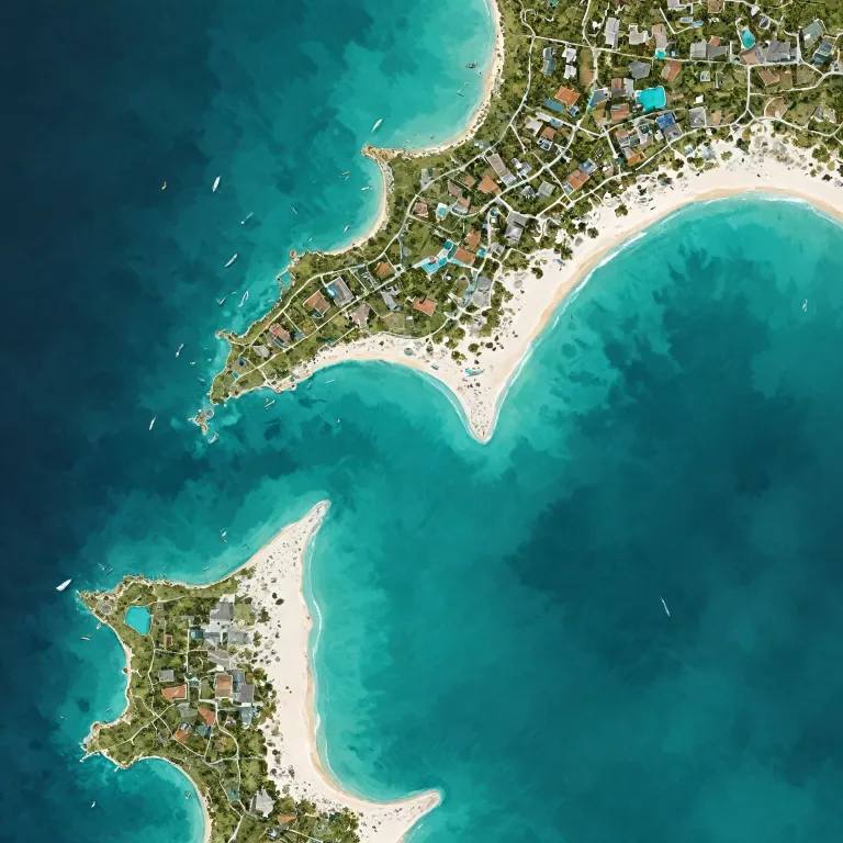
On most maps, Cancun appears on the northeast of the Yucatán Peninsula, facing Isla Mujeres and close to Isla Holbox further northwest. South along the same peninsula, the Riviera Maya unfolds for about 120 kilometres, with Puerto Morelos, Playa del Carmen, Puerto Aventuras, and Tulum aligned like pearls. Understanding this geography lets you balance resort privacy with proximity to nightlife, golf, and fine dining.
High end travellers often use a detailed hotel map to visualise how their chosen property sits between the Caribbean Sea and the Nichupté Lagoon. A precise map of Cancun and Riviera Maya also shows road connections to Chichén Itzá and other Mayan sites in Yucatán, which is essential for planning private excursions. When you compare several maps, prioritise those that clearly mark luxury resorts Cancun side by side with premium addresses along the wider Cancún Riviera corridor.
Specialist publishers such as Franko Maps and resorts like Grand Velas Riviera Maya provide laminated maps and digital maps that highlight beaches, cenotes, and archaeological zones. These maps top many travellers’ packing lists because they withstand humidity and frequent handling. For visually engaging planning, the illustrated work of Felix Diaz de Escauriaza adds character while still respecting accurate geography.
Choosing your luxury base along the Riviera Maya coastline
Reading a map of Cancun and Riviera Maya helps you decide where to stay according to your travel style. Cancun in Quintana Roo suits guests who want a dynamic atmosphere, with tall resorts Cancun facing the sea and easy access to shopping and nightlife. Further south, the Riviera segment becomes quieter, with more space between each hotel and more direct access to nature.
Playa del Carmen sits roughly midway on the Riviera Maya map, making it ideal for travellers who want to split time between Cancun and Tulum. When you look at maps of the Yucatán Peninsula, you will see how Playa del Carmen and the adjacent area of Playa del Carmen del Carmen form a central hub for ferries to Cozumel and excursions inland. A hotel map here often highlights walking distances to Fifth Avenue, beach clubs, and private piers.
Puerto Morelos offers a calmer alternative between Cancun and Playa del Carmen, and many premium properties here emphasise wellness and reef access. On a detailed map riviera overview, Puerto Morelos appears close enough to Cancun airport for short transfers yet far enough to feel secluded. South of Playa del Carmen, Puerto Aventuras provides marina front stays that appeal to guests who prioritise yacht charters and sport fishing.
Tulum lies at the southern end of the main Riviera Maya strip, and its position on the map of Cancun and Riviera Maya is strategic for exploring Sian Ka’an and lesser known Mayan sites. When you read several maps top to bottom, you will notice how the road continues beyond Tulum into wilder stretches of the Mayan Riviera. Choosing between Cancun, Playa del Carmen, Puerto Aventuras, and Tulum depends on whether you value vibrant evenings, central positioning, marina access, or bohemian seclusion.
Using maps to plan premium excursions across the Yucatán Peninsula
A refined itinerary along the Caribbean coast always extends beyond the immediate hotel map. When you study a detailed map of Cancun and Riviera Maya, you can trace day trip routes to Chichén Itzá, Valladolid, and cenote clusters across the wider Yucatán Peninsula. This broader perspective ensures that your luxury stay in Mexico includes both coastal relaxation and cultural depth.
From Cancun or Playa del Carmen del Carmen, the road to Chichén Itzá crosses the state line between Quintana Roo and Yucatán, which you will clearly see on most maps. Planning with accurate maps top quality helps you estimate driving times for private chauffeured transfers or helicopter charters. Many high end travellers prefer laminated Franko Maps or resort issued maps because they combine road details with icons for cenotes, haciendas, and Mayan ruins.
Along the Riviera Maya, a good maya map will also show eco parks such as Xcaret and Xel Há, which are popular for families staying in resorts Cancun or Playa del Carmen. When you read these maps carefully, you can sequence activities so that snorkelling, spa appointments, and fine dining align smoothly. The same maya map often highlights lesser known archaeological zones that pair well with a visit to Tulum’s seaside ruins.
Offshore, Isla Mujeres and Isla Holbox appear on the northern section of most map cancun references, while Cozumel sits opposite Playa del Carmen. Including these isla destinations on your map riviera planning allows you to integrate whale shark encounters, sailing, or secluded beach days. For guests who value privacy, plotting these islands on a detailed map of Cancun and Riviera Maya helps you decide whether to split your stay between mainland and island hotels.
Interpreting hotel maps for premium stays in Cancun and Riviera Maya
For luxury travellers, the most important document after a reservation confirmation is often the hotel map. A precise hotel map within Cancun or along the Riviera Maya shows room categories, pool locations, spa facilities, and beach access in relation to the wider map of Cancun and Riviera Maya. This level of detail helps you choose suites that match your preferences for sunrise views, quiet corners, or proximity to restaurants.
Many premium properties in Quintana Roo now provide interactive maps that overlay the resort layout onto a broader maya map of the surrounding area. When you read these digital maps, you can see how close your maya hotel is to golf courses, marinas, or protected mangroves. This is particularly useful in areas like Puerto Aventuras, where marina front suites may differ significantly from oceanfront rooms.
In Cancun, a hotel map usually distinguishes between lagoon side and sea facing towers, which can affect both noise levels and sunset views. Along the Riviera Maya, especially near Playa del Carmen and Puerto Morelos, maps top quality often indicate reef locations and snorkelling entry points. Guests who value calm swimming conditions should pay attention to these details on the map riviera overview before finalising their booking.
When comparing properties across the Mayan Riviera, look for maps that clearly mark walking paths, buggy routes, and distances in metres. This is essential on large estates in Quintana Roo, where a suite may be several hundred metres from the main lobby. For inspiration on how a resort can present its layout elegantly, you can read this detailed resort feature, which illustrates how clear mapping enhances the guest journey : experience the elegance of a coastal spa resort.
Balancing coastal glamour and Mayan heritage through careful map reading
The true art of using a map of Cancun and Riviera Maya lies in balancing coastal glamour with Mayan heritage. When you read both printed maps and digital maps of the Yucatán Peninsula, you can design days that move gracefully from spa rituals to archaeological exploration. This approach suits guests who want their time in Mexico to feel both indulgent and meaningful.
Along the Caribbean coast of Quintana Roo, the mayan riviera label on many maps highlights how culture and shoreline intertwine. A detailed maya map will show not only Tulum but also secondary sites inland, which pair well with cenote swims and hacienda lunches. By plotting these on your personal map cancun overview, you can avoid backtracking and reduce time spent in transit.
Isla Mujeres and Isla Holbox, often placed near the top of regional maps, offer a softer rhythm that contrasts with the energy of Cancun. When you include these isla retreats on your hotel map planning, you can schedule two or three nights of barefoot luxury between busier stays in resorts Cancun. The same logic applies to Puerto Morelos and Puerto Aventuras, which appear as quieter dots on the map riviera yet deliver high comfort levels.
As you refine your itinerary, remember that “Detailed maps are available through publishers like Franko Maps and at local tourist information centers.” These resources, combined with resort concierge advice, help you interpret the mayan landscape respectfully. In practice, this means allowing enough time at Chichén Itzá and other sites in Yucatán to appreciate their significance rather than treating them as quick photo stops.
Practical mapping tips for seamless luxury stays in Cancun and Riviera Maya
To make the most of any map of Cancun and Riviera Maya, start by clarifying your priorities. Some travellers focus on spa and gastronomy in Cancun and Playa del Carmen, while others emphasise nature and archaeology across the wider Mayan Riviera. Your map should reflect these preferences through highlighted routes, estimated times, and notes on hotel locations.
Use laminated maps for boat trips, cenote excursions, and jungle adventures, as they resist water and frequent folding. Digital maps complement them by offering live positioning along the Caribbean coast of Quintana Roo, especially when driving between Cancun, Puerto Morelos, and Tulum. Combining both formats ensures you always have a reliable reference, even when mobile coverage is weak.
When you read a hotel map, pay attention to scale and legend, which indicate how far facilities are from your suite. In expansive resorts Cancun or large estates near Playa del Carmen del Carmen, distances can be greater than they appear at first glance. Clear legends on maps top quality will also show elevation changes, which matter for guests with mobility considerations.
Finally, keep a dedicated folder or digital album for your maps of the Yucatán Peninsula, including any personalised maya map versions created by concierges. Over several trips to Mexico, this archive becomes a valuable reference for comparing different areas of Quintana Roo and beyond. It also helps you refine future stays, whether you return to Cancun Riviera properties, explore new corners of the Riviera Maya, or extend your journey deeper into Yucatán and the surrounding peninsula.
Key figures for the map of Cancun and Riviera Maya
- The Riviera Maya coastline extends for approximately 120 kilometres along the Caribbean Sea.
- The population of Cancun is estimated at around 888 000 people within the urban area.
Essential questions about using maps in Cancun and Riviera Maya
What are the must-visit attractions in the Riviera Maya ?
Key attractions include the Mayan ruins at Tulum, the beaches of Playa del Carmen, and the eco-archaeological park Xcaret.
How can I obtain a detailed map of Cancun and the Riviera Maya ?
Detailed maps are available through publishers like Franko Maps and at local tourist information centers.
Are there guided tours available in the Riviera Maya ?
Yes, numerous guided tours are available, covering historical sites, natural attractions, and adventure activities.
